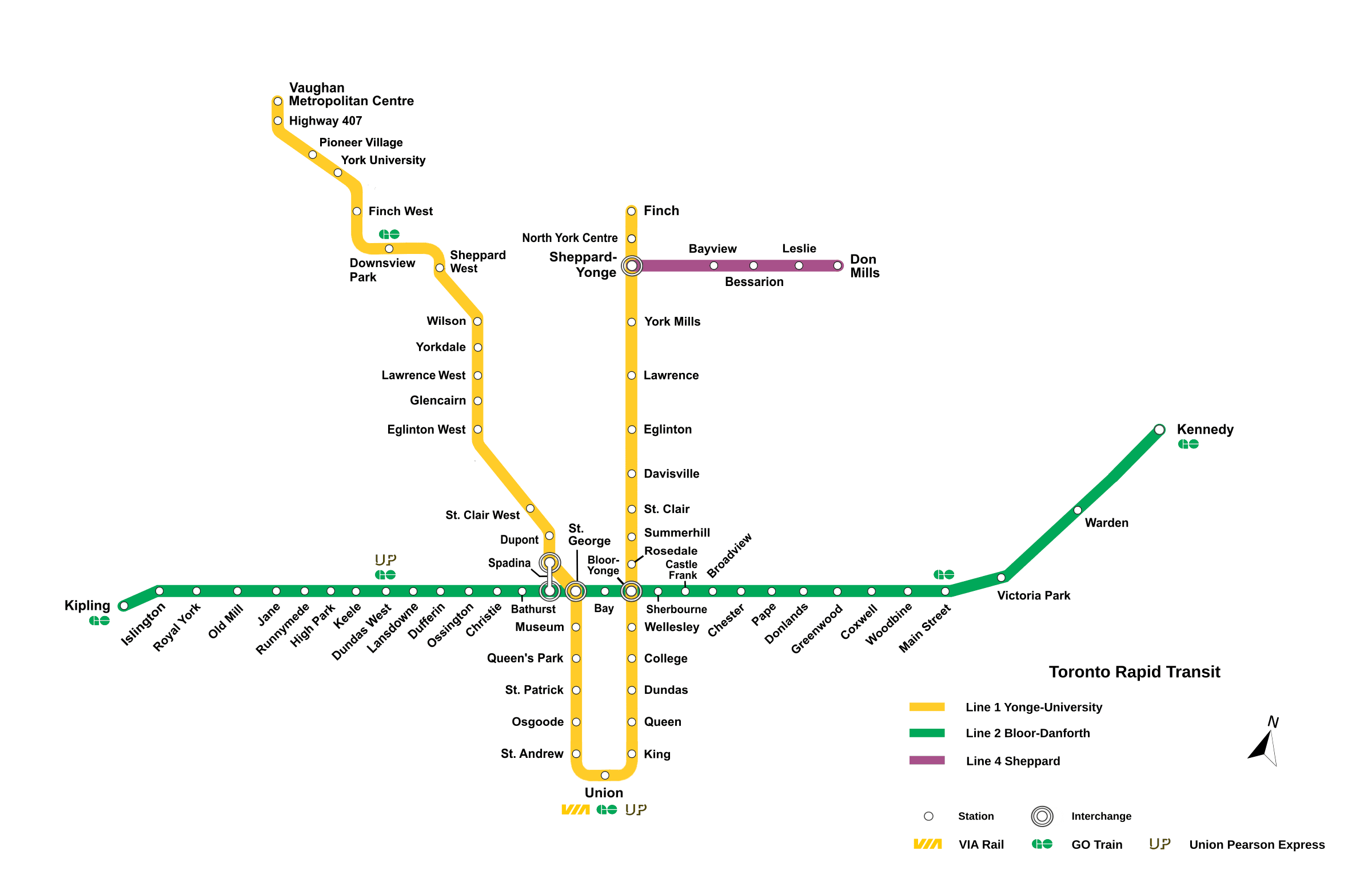
Toronto subway map
Lines 1, 2 and 4 and their 70 stations on one map, also as a PDF
The network map
 Enlarge
Subway map as a PDF
Vector and sharp at any size, even printed at A3.
What the map shows
This map is drawn by us from the data: which stations exist, the order they come in, the colour of each line and where they are. Those are facts, and facts belong to no one. The coordinates of the 70 stations come from open data, and that is what this map is built on.
What it shows first is the shape of Line 1, a long U through the centre of the city, crossed by Line 2 from end to end — the two meet at Bloor-Yonge, St George and Spadina — and that the network reaches well beyond downtown, out to North York, Scarborough, Etobicoke and Vaughan.
| Line | Route | Stations | Length | Shared stations |
|---|---|---|---|---|
| 1 | Finch – Vaughan Metropolitan Centre | 38 | 36,92 km | 4 |
| 2 | Kipling – Kennedy | 31 | 25,99 km | 3 |
| 4 | Sheppard-Yonge – Don Mills | 5 | 5,42 km | 1 |
Every station by line
In order, terminus to terminus. Tap a station for its times and what is nearby.
Finch – Vaughan Metropolitan Centre
38 stations · 36,9 km · 76 minutes end to end
Kipling – Kennedy
31 stations · 26 km · 52 minutes end to end
Frequently asked questions about the subway map
Yes. The PDF above is vector: it stays sharp at any size, even printed at A3.
Yes, with attribution: the map is ours and under CC BY 4.0, and the data underneath is open. Details on the sources and licences page.
Because the subway reaches right across Toronto: 44 of the 70 stations are in North York, Scarborough, Etobicoke or Vaughan rather than downtown.
At Bloor-Yonge, St George and Spadina between Line 1 and Line 2, and at Sheppard-Yonge between Line 1 and Line 4. At each you change platforms or levels to switch lines.